How it works

Contents
The basics
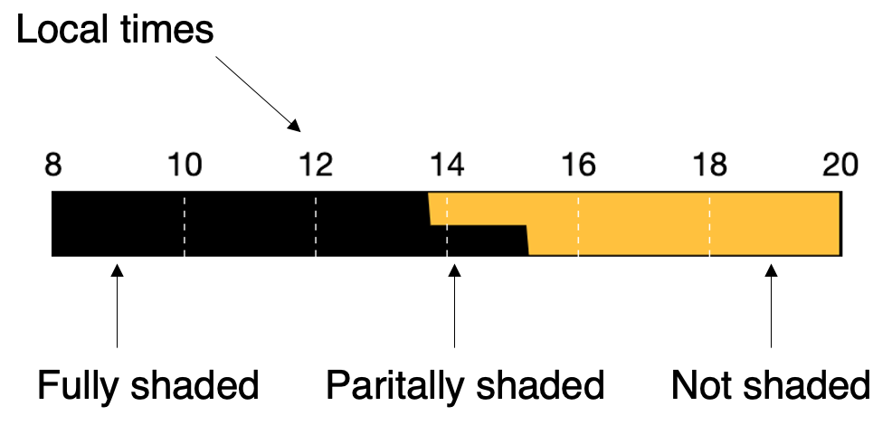
On top you have the local time of day. Black means shade. Yellow means sun. When the diagram is part yellow and part black, the sector is partially shaded and the amount of black vs yellow represents how much of the sector is shaded.
We do not consider shade from trees or clouds, only from the rock itself.
What does partially shaded mean exactly?
If you see half shade, half sun, it usually means that half the routes are shaded, but in rare cases could also mean that all routes are half shaded or something in between. These rare cases usually happen in sectors that are not very uniform, meaning the wall has features such as big corners, bulges or curves.
How accurate is it? - Short answer
When you see the sector is fully shaded or fully in the sun, that's almost always accurate. The sharp transitions from fully shaded to fully in the sun are usually accurate to within 15 - 30 minutes. When you see the sector is partially shaded, or a gradual change, you should consider the information as a rough estimate.
In any case, it's way more accurate than saying "morning shade" or something similar as most guidebooks say...
For more details see the long answer below
How do you get this information?
The first step is to map the sector. This can be done from a satellite photo for simple vertical or near-vertical walls. For the more complicated sectors with corners, caves, bulges etc., a field mapping might be needed.
The second step is to run the map of the wall through our app which takes the sun's angle and direction at a given time, and then uses the shape of the wall to calculate how much of it is shaded. This calculation is never 100% correct but is usually good enough.
What about summer daylight saving time?
We do consider daylight saving time so the times you see should always be correct local time.
How accurate is it? - Long answer
Accuracy depends a lot on 2 factors, how complex the shape of the sector is, and how good the mapping is.
Uniform vertical walls - The simplest walls are uniform vertical or near-vertical and without any big features, corners or other changes. For these walls, the diagram should be spot on with a sharp transition from fully shaded to fully in the sun. For these walls all we need to know is the exposure direction, which can be measured pretty well from satellite images.
Uniform slabs or overhangs - A slightly more complex case, but still pretty simple, is a uniform slab or overhang. In this case we need to measure the exact angle of the wall in addition to the exposure direction.
Complex walls - Walls which have corners, bulges, curves or other complex features, require some sort of 3D mapping to get a reasonable result. Theoretically, with a perfect 3D mapping we could give a perfect result down to which specific hold is shaded. In practice we'll only take a reasonable amount of measurements. This means that for this type of sectors, the information is less accurate, but still useful and definitely better than nothing.